
JPMorgan has downgraded Indian equities to 'neutral' from 'overweight', citing elevated valuations, rising earnings risks, and limited exposure to next-generation technology like AI. The brokerage believes other emerging markets offer more attractive risk/reward propositions despite India's strong structural growth story.

The civil aviation ministry is monitoring the impact of volcanic ash plumes from Ethiopia on flight operations, leading to cancellations and delays. The situation is being closely monitored, and necessary precautions are being taken.

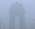
Delhi experienced a foggy morning with a dip in temperature and improved air quality following recent rainfall. The air quality index (AQI) reached 'satisfactory' levels for the first time in five months.

Schools in Delhi are taking precautionary measures to protect students from the ongoing heatwave, including suspending outdoor activities, shifting assemblies indoors, and considering early closure for junior classes.

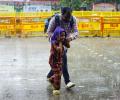
A new western disturbance brought thunderstorms and rain to parts of northern India, with hailstorms and snow reported in several regions. The weather caused flooding in Jammu and Kashmir and prompted a yellow alert in Delhi.
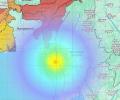
An earthquake of magnitude 6 with its epicenter in Myanmar jolted Kolkata and its adjoining areas, causing tremors and concern among residents.

On the weather front, dense fog led to a sharp drop in visibility, with Palam recording 50 metres visibility under dense fog conditions with west-southwesterly winds at 5 kmph at 8 am, while Safdarjung reported 100 metres visibility with calm winds at the same time.

Several states in north India, including Rajasthan and Himachal Pradesh, experienced varied weather conditions, including light to moderate rainfall, fog, and temperature fluctuations.

Delhi recorded its coldest January morning in three years with the minimum temperature dropping to 3 degrees Celsius. Cold wave conditions are expected to persist, and air quality has deteriorated to the 'very poor' category.

'Monsoon is the pran (life) of our water system.' 'A weak monsoon will have a very negative impact on crops and people's lives.'

Dense fog disrupted operations at Delhi airport, leading to cancellations and delays of hundreds of flights. Airlines are offering refunds and rescheduling options.

Sri Lanka's Department of Meteorology issued a special bulletin on Friday morning, warning the public about possibility of rain in Colombo on Sunday.
The wind speed, reaching 45-55 kmph and gusting to 65 kmph, is likely to prevail over the North Maharashtra coast between October 3 and 5.

Early morning rain in Delhi lowers temperatures. The weather office predicts cloudy conditions and thunderstorms for the day due to a western disturbance.

The winters could be cooler in the plains due to the prevailing La Nina conditions though it does not have a direct relationship and also due to influence of the polar vortex.

The India Meteorological Department (IMD) has issued a 'red alert', warning of extremely heavy rainfall in Mumbai, Thane, Raigad and Palghar districts on Sunday, extending the wet patch in the region.

Cyclone Shakhti, the first cyclonic storm of the post-monsoon season in the Arabian Sea, has intensified.

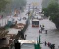
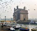
Several parts of Mumbai received heavy rainfall in the last 24 hours, with Vikhroli reporting the highest downpour. The IMD reported significant rainfall in various areas of the city.

The national capital was in the grip of a cold wave, with the sun largely obscured by clouds and pollutants lingering in the atmosphere, leading to reduced visibility. At least 129 flights were cancelled at the Delhi airport on Saturday due to dense fog, according to an official.

Delhi's air quality deteriorated to the 'severe' category, prompting the implementation of Stage-IV GRAP measures and hybrid classes for schools.

Delhi's air quality deteriorates to 'very poor' levels, sparking a blame game between AAP and BJP over the causes and responsibility for the pollution.
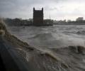
Cyclone Ditwah is moving towards the Tamil Nadu coast, bringing the threat of heavy rainfall. The state government is reviewing preparedness measures, and a red alert has been issued for southern and delta districts.

A severe cold wave has intensified across North India, with Delhi recording its lowest temperature of the season. Rajasthan experienced sub-zero temperatures, and several states have issued alerts and closed schools due to the extreme conditions.

"Montha over westcentral Bay of Bengal moved north-northwestwards with a speed of 17 kmph during the past six hours and lay centred at 2.30 am on October 28 over the same region about 230 km south-southeast of Machilipatnam (and) 310 km south-southeast of Kakinada," said the Met Department in a release.

A thick layer of toxic smog enveloped the national capital on Saturday as air quality deteriorated sharply, prompting the Commission for Air Quality Management (CAQM) to invoke the strictest curbs under Stage IV of the Graded Response Action Plan (GRAP) across Delhi-NCR.

'We should expect extreme heat, extreme rains, floods, landslides and maybe cyclones. Not just this year, in the coming year as well.'

The IMD has predicted "heavy to very heavy" rainfall in Mumbai on Sunday.

Above-normal cold wave days are expected in some areas of central India, eastern Uttar Pradesh and Bihar during January 2026.
The India Meteorological Department issued an orange alert of heavy rains for Mumbai for Wednesday, and predicted the intensity of rainfall in the metropolis will go down from Thursday.
The heatwave alert has been issued for Mumbai, Thane, Raigad and Ratnagiri on February 25 and 26, the IMD said.

In a post on X in the morning, IndiGo said there was heavy downpour over Delhi, causing some temporary disruption to flight schedules.

Delhi choked under a thick blanket of smog on Monday, with the Air Quality Index (AQI) settling at 498, which falls in the higher spectrum of 'severe' category.

The IMD has red and orange alerts for the hours ahead.

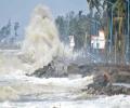
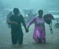
Heavy rains continue to batter Tamil Nadu, causing a rise in reservoir levels and prompting a red alert. Schools and colleges are closed in several districts as authorities prepare for potential flooding.
The India Meteorological Department (IMD) reported that very dense fog began forming around 5.30 am, resulting in a thick haze over different parts of the national capital.
For March 22, an Orange Alert has been issued while a Yellow Alert has been issued for Sunday.
The India Meteorological Department (IMD) has predicted above-normal rainfall for most parts of India during the post-monsoon season (October to December), except for some areas in the northwest. The southwest monsoon season ended with the country recording eight per cent above normal rainfall.

Mumbai recorded its coldest day on Monday since December 24, 2015 with the temperature dipping to 13.7 degrees Celsius, an India Meteorological Department official said.

The aircraft, later, flew to Guwahati after an improvement in the weather conditions in Guwahati, said KC Meena, the director of the Maharaja Bir Bikram (MBB) Airport at Agartala.
The record monsoon rains across India during the June to September months was 937.2 millimetres, the 5th-highest since 2001 and 38th-highest since 1901.